

Introduction
This is the first in a series of pages describing the origin of the routes around and through Meldreth and how they have changed over time, before concluding with the background to the current street names.
Ancient Routes around the Village
Meldreth lies in the upper Cam valley which is about 18 kilometres long and 9 kilometres wide. In the early nineteenth century the village was comprised of five separate groups of dwellings or hamlets which then gradually amalgamated into one settlement.
To the north, the valley is bounded by the Greensand ridge that runs from Bedford to Barrington (about 70 metres at its highest point) after which it drops steeply into Haslingfield. This ridge is intruded by chalk areas, a hard chalk forming the base of the valley. On the other side, the ground rises to the east past Melbourn through a series of terraces to the softer chalk ridge which runs through Heydon at about 100 metres. Both chalk ridges are spurs of the Chilterns.
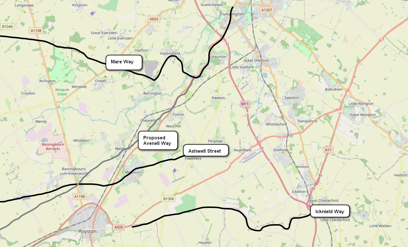
There are several ancient trackways that pass near the village (Fig 1).
These trackways tended to follow the higher ground and the valley was probably prone to flooding. The Shepreth historian John Layer in 1634 described Meldreth as “standeth somewhat lowe and ye soil is deep and fertill”.
Mare Way
To the north was the Mare Way which runs along the northern ridge from north of Wimpole linking up with other routes into Cambridge through Chapel Hill above Haslingfield. It may have been a pilgrimage route.
Ermine Street
Another ancient route was what is now called Ermine Street from its conversion into a Roman road. This runs due north from Royston across the Upper Cam Valley and was one of the key Roman routes (see below) from London to the north.
Ashwell Street
Another route which was straightened and became a Roman road was Ashwell street from Ashwell, which was part of the Icknield Way. It passes through Melbourn very close to the Bury site, where the River Mel rises. This may have been the headquarters of the local Anglo Saxon chieftain Melde. It is probable that his lands were subdivided between Meldreth and Melbourn.
Icknield Way
The Icknield Way was a major network of paths (differentially used depending on the seasons) linking east to west and providing important routes both for travellers and animals. They link East Anglia to the lower Midlands along the southern edge of the Fens. The Icknield Way extends through the Chilterns to link with the Ridgeway, which runs on to the south coast at Lyme Regis. Eastwards, the route links with the Peddlar’s Way running on to the Norfolk coast. It is considered to be the oldest surviving pathway network in England. The name first appears in written form in the early 10th century as Icenhylte, and it may refer to the Celtic Iceni (Boudica’s people) that inhabited Norfolk and Suffolk in the Iron Age. Some scholars suggest that it may even have been in existence when England was still connected to the continent by a land route.
Both the Icknield Way and Ermine Street were one of four highways that appear in 1130s road documentation. This indicated that they had been constructed by royal authority and the “Leges Edwardi Confessoris” gave royal protection to travellers on these roads. Matthew Paris, around 1250 showed them on a map of Britain called Scema Britannie. The Icknield Way is depicted by a straight line from Salisbury (i.e., Old Sarum) to Bury St Edmunds which intersects the other three roads near Dunstable.
It is very noticeable that there is a line of barrows and tumuli along these routes indicating their significance to the prehistoric and Anglo Saxon inhabitants of the area.
Avenell Way
A recently discovered route, now named the Avenell Way, ran from Odsey to Cambridge. This trackway linked to Ermine street, Ashwell Street and the Icknield Way. Evidence suggests that this was established in the late Iron Age and continued to be used into the post mediaeval period. The Cambridge end then became absorbed into the route that eventually became the A10. The only evidence of it in Meldreth is at the curved northern boundary of fields in Chiswick End and then in a field to the east of the High Street where is can be seen in an aerial photograph. It is then picked up again skirting a hill to the south. It is postulated that it crossed the River Mel near the present site of the British Queen. Details of this route can be found in the Proceedings of the Cambridge Antiquarian Society, volume 103 (2014).
New trackway in Melbourn
Evidence of another trackway running roughly south west – north east along the ridge was recently discovered during an archaeological dig at a housing development off New Road in Melbourn.
Larger network of paths
There is historical evidence for these major local routes, but in addition there is likely to have been a network of local pathways used at different times of the year, depending on conditions, to connect settlements. Some of these remain as our footpaths, but many were lost at enclosure and with defensive farming practices.
Roman Roads
Figure 2 shows the Roman roads in the neighbourhood.
The Romans were well known for their road building, especially to connect their military camps and major towns. Three are in the vicinity of Meldreth. Ermine Street, following the ancient trackway, ran from London to Lincoln and then connecting to the north. The A603 follows the route of a Roman Road from Bedford to Cambridge, intersecting Ermine Street to the north of Royston. The third follows the route of the Icknield Way trackway along the stretch near Meldreth from Royston, also intersecting with Ermine Street in Royston. The modern A505 follows the ancient trackway route and then the Roman road from Baldock to Royston but then follows a new route to the north of the Roman road.
See also our page on Highways and Byways in the Medieval Period


No Comments
Add a comment about this page